
Indoor And Outdoor Wayfinding Technology For Vision-Impaired People
Navigating an unfamiliar place is uniquely challenging for people with disabilities. People with blindness, deafblindness, visual impairment or low vision, as well as those who use wheelchairs, can travel more independently in urban areas with the aid of effective wayfinding technology. A new report from the National Institute for Transportation and Communities (NITC) explores how to leverage low-cost methods to enable people to more easily move through public, urban indoor and outdoor spaces.
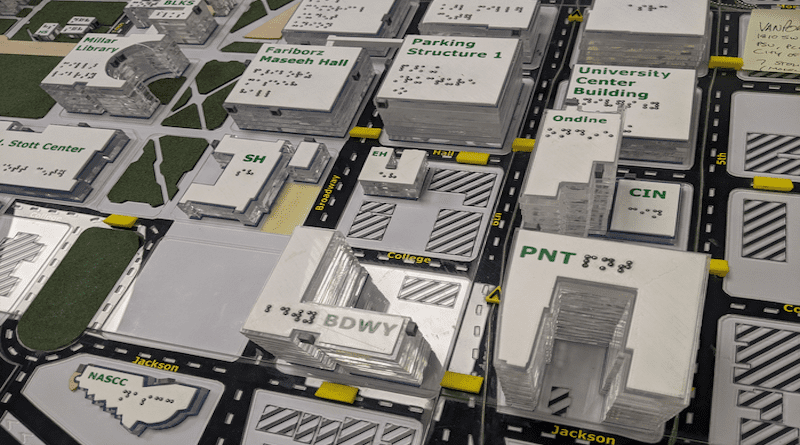
The study, led by Martin Swobodzinski and Amy Parker of Portland State University, used focus groups, two case studies, and an in-person structured wayfinding experience on the PSU campus to find the most helpful ways of getting around. Tactile maps were found to be a very useful resource, with an accessible mobile app also showing promise as an orientation and mobility aid.
WHY IS THIS RESEARCH IMPORTANT?
Environments and wayfinding tools that support safe, confident mobility have been linked with improved employment outcomes, more access to higher education, and better quality of life. The results from this study improve our understanding of how people with visual impairment and blindness find their way through the world. Researchers are hopeful that the insights from the study will support the development of standards and innovation in mobile wayfinding as it relates to the integration of indoor and outdoor wayfinding, and routing for visually impaired, blind, and deafblind pedestrian travelers.
Despite the proliferation of wayfinding apps that are meant to benefit travelers, the effectiveness of such tools remains limited. This study gave voice to the experience of diverse travelers who use wayfinding technologies to accomplish important life tasks. In addition to the findings discussed in more detail below, researchers hope the analysis of the remaining data will drive forward a better understanding of the information needs of visually impaired, blind, and deafblind pedestrian travelers.
RESEARCH METHODS
The project sought answers to three questions:
- What are the preference structures, information needs, and expectations of individuals with visual-impairment, blindness, and deafblindness towards wayfinding in public indoor/outdoor spaces?
- How can low-cost wayfinding technology (e.g., digital maps, spatial data, personal telecommunication devices, and low-energy beacons) be leveraged best to allow for the seamless wayfinding of pedestrian travelers with functional disabilities in public urban indoor/outdoor spaces?
- Which wayfinding technologies, data products, and technology platforms afford a sustainable, scalable deployment in a large academic institution?
College campuses are notoriously complex to navigate, particularly for travelers with visual impairments. One of the key barriers for culturally and linguistically diverse people in accessing higher education is seeing themselves as full members of a college campus community. As a public university situated in the heart of downtown Portland, the PSU campus was an ideal setting for this experiment as it affords realistic wayfinding scenarios and mobility challenges in a public urban environment. In addition, PSU’s commitment to community service, equity, and inclusivity align with the project’s goals of promoting community participation and access.
WAYFINDING EXPERIMENT
In a larger experiment, participants were invited to partake in a series of wayfinding tasks, navigating three short routes on campus with both indoor and outdoor elements. Accompanied by an experimenter with professional experience in Orientation and Mobility, participants were asked to travel two different routes while using one of two possible wayfinding supports: a tactile map for one route, and the GoodMaps mobile app for the other.
A total of 28 people participated in the main data collection phase of the study and completed the experiment: 21 adolescents (between the ages of 14 and 18) and seven adults. Participants included people of color, LGBTQIA+ individuals, and people with varying levels of visual impairments. The immediate next step for the research team is consolidating individual-level data for each of the 28 participants, and coding and assessing their observed wayfinding behavior and performance. While data analysis is still in progress for the 28 participants, early findings from the two case studies indicate that the tactile map afforded the most effective wayfinding support.
FOCUS GROUPS
The research team conducted two focus groups, one with eight blind or visually impaired adults who did not have any hearing loss, and another with nine deafblind participants who use Tactile American Sign Language or close-range visual American Sign Language. Collective themes from the two focus groups included both the hope and promise of wayfinding apps for offering greater environmental literacy during real-world travel, and the limitations of using such apps.
Both groups expressed the need for apps to be designed in collaboration with travelers with visual impairments, because of the apps’ unique limitations in dynamic travel conditions. A specific theme that emerged amongst visually impaired travelers was that they have to use multiple apps to complete a single route, because each app is useful for a subset of wayfinding tasks.