
Coca Farms Close In On Protected Areas, Isolated Tribes In Peruvian Amazon – Analysis
By Mongabay
By Chris Fagan*
Pascual cuts the motor and our dugout canoe glides below a massive tree trunk suspended a few feet above the river. I motion to the bank.
“We want to fly the drone!” I yell over the buzz of chainsaws coming from the opposite bank.
“No,” Pascual says, shaking his head. “We can’t stop here … the trees will fall on top of us … and these people are dangerous.”
Pascual is Yine, one of a half-dozen tribes that live on the Sepahua River, a tributary of the Urubamba in the remote headwaters of the Peruvian Amazon. He’s the coordinator of the Sepahua vigilance committee, volunteers who help guards protect the buffer zone of Alto Purús National Park. We’ve come to verify rumors of a massive land invasion in the park’s buffer zone, and for the past week Pascual and three other local men have led us up the small river through a patchwork of mature jungle and brand-new clearings. The contrast is striking and disturbing. One moment it feels like the heart of the Amazon. Scarlet macaws fill the sky, and we count tapir and ocelot tracks on the muddy banks. And the next, the trees are gone and the air is full of smoke and ash from the burning fields that surround our boat.
Pascual pulls the starter cord and the canoe lurches forward. A moment later a tremendous cracking drowns out the motor as another giant tree crashes down the bank and explodes into the river behind us.
A new frontier for an illegal industry
The men cutting the trees are from VRAEM, the Valley of Apurímac, Ene and Mantaro Rivers, a region notorious for terrorism and as the largest producer of cocaine in Peru. The movement of coca farmers from VRAEM to unpopulated lowlands isn’t new. Coca eradication programs focused on the Andean foothills have displaced growers for decades, but nowhere near the scale and speed of what we’re witnessing now. Within a few months, the Sepahua has been transformed from a sleepy frontier town to a bustling hub of outsiders moving up and down the river in large metal boats brought from the city of Atalaya. Local Yine, Asháninka and Amahuaca tribespeople, whose ancestors settled here generations ago, are living in fear as they helplessly watch the forest they depend on disappear.
But they aren’t the only ones being impacted by the lawlessness. The Sepahua is part of the Purús-Manu Conservation Corridor, a massive 10-million-hectare (25-million-acre) complex of protected areas and indigenous lands twice the size of Costa Rica. This area is one of the most biodiverse places anywhere on the planet, and harbors one of the largest concentrations of isolated peoples. The Sepahua provides access to Alto Purús and Manu national parks and two reserves set aside for the isolated tribes. As the invaders move further upstream toward the protected areas, the territory for some of the world’s last isolated tribes continues to shrink.
Our first day on the river we pass the control post for Alto Purús National Park, intended to prevent illegal activities in the buffer zone. The front of the building is covered with termite nests and the surrounding forest has been cut and replaced with partly burnt trees and manioc bushes. It hasn’t been staffed in more than two years and farmers have taken it over. The scene is discouraging and portends the next week on river.
Soon after passing the post, one of our Amahuaca guides points to the riverbank.
“Here is where the parcels start.”
A large tree has recently been cut to create an opening in the otherwise dense forest perpendicular to the river. “P1” is painted in red on a standing tree next to the clearing, marking this place as Parcel No. 1.
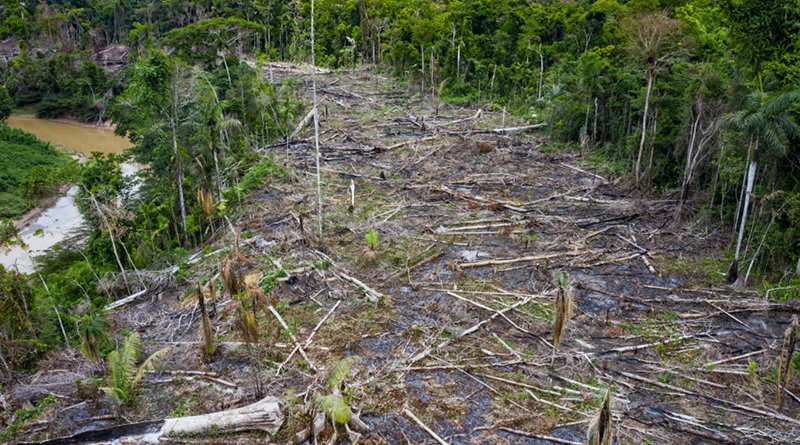
Over the next week we count 180 parcels on the right bank and 74 on the left. They’re 100 percent illegal, cut from forest zoned for sustainable and selective logging and divided into timber concessions. Some are spaced 200 meters (650 feet) apart, others 300, and they all extend 1,000 meters deep into the forest, thus covering 20 and 30 hectares (50 to 70 acres), respectively. Not all are occupied, however. Of the 254 parcels, 73 are in some stage of clearing, the fields ranging from 1 to a few hectares. Most have been cut within the past few months, and they appear newer as we move upstream. The last one we find is located less than 10 kilometers (6 miles) from the park boundary.
We don’t see any coca crops along the river, but we didn’t expect to. The coca is grown deeper in the forest, hidden from passing boats, while these riverfront farms are planted with crops like cacao, maize and manioc and reportedly serve as a front to justify the farmers’ presence.
The movement of coca farmers from traditional growing areas in the Andean foothills to the lowlands began decades ago but has increased significantly over the past 20 years in response to an increase in eradication programs. Protected areas are often targeted due to their remoteness, arable soil and the lack of government presence. Eradication efforts in Peru have focused on VRAEM, and in addition to destroying coca fields, include programs to help farmers transition to legal crops like cacao and coffee. However, a decrease in coffee prices and delays in the process of certifying organic beans is making coffee less profitable and may be causing farmers to abandon coffee and turn back to coca. Furthermore, legal farmers are finding it difficult to grow their crops in areas where coca is still prevalent. In early November, 3,000 cacao- and coffee-farming families in VRAEM demanded the government intervene to prevent chemical contamination from illegal coca plantations that are hindering the certification process for the beans and lowering prices.
Despite millions of dollars spent on eradication, the continued robust demand for coca has resulted in continued production. In 2018, Peru cultivated enough coca to produce 509 metric tons of cocaine, a steady increase from the 307 tons it could have produced in 2012, according to U.S. data.
Empty promises, dangerous lies
One of our guides, Guillermo, is a mechanic and has a chainsaw part for one of the new farmers, so we take advantage of the opportunity and follow him up the steep riverbank to a new clearing. It looks to be only a few months old and about 2 hectares (5 acres) in size. Partially burned logs lie in the ash among manioc plants and a few skinny papaya trees. A couple and two young girls are sitting on the roughly sawn floorboards of an open-sided house with a palm-thatched roof. A deer skin is drying next to several plastic gas containers and three chainsaws.
Despite the ugliness of the clearing, these are not the threatening narcos I expected. The younger girl holds a parrot in front of her to hide her smiling face, and the man, who says his name is Carlitos, seems friendly enough. We make small talk as Guillermo and Carlitos hunch over a chainsaw. Theirs is the typical story. They arrived six months ago from VRAEM. I ask if the land is theirs.
“No, we aren’t the owners, it’s the state’s,” Carlitos says. “We heard it was available, so we came with the head of the association. They are going to build two towns here, one for each association, with schools, everything. Soon there will be 5,000 people living here.”
We learn that the farmers were recruited by land traffickers to join agriculture associations focused on growing cacao, yet the associations don’t have any rights to the land. Carlitos tells us that engineers from Peru’s protected areas agency, SERNANP, marked and mapped the parcels. However, this is obviously false as that function is not within the agency’s jurisdiction. He said he then paid a fee of 2,400 soles ($800) to occupy his parcel. His hope is that the government will see that the lands are being used and eventually grant him ownership. This scenario could be possible in lands not already set aside for other uses, but the Sepahua is zoned for forestry as Permanent Production Forest Units and divided up into forestry concessions. Unfortunately for Carlitos, the law dictates that he has next to zero chance of ever legally occupying his parcel.
The tone of our conversation takes a dramatic turn when we pull out our cameras. The wife and girls disappear, and Carlitos grabs a sweatshirt, pulling the hood over his head despite the sweltering heat. Then the older of the girls appears with a phone and points it in my face taking pictures. I notice that Guillermo is already making his way down the path. “Chris, it’s time to go,” he says.
Later that day I ask Pascual about Carlitos.
“We don’t know the people making that farm,” he said. “The truth is that I don’t understand how they came here, how someone sold this land … if they keep coming, making more farms, we won’t be able to fish or hunt on this river. I don’t want any more people to come. You’ve seen what they have destroyed. Maybe you can help stop this?”
The previous day we talked to two fishermen from VRAEM who in two days netted 160 fish totaling more than 300 kilograms (660 pounds), which they sold in town. If the fish and peccary and deer disappear, people like Pascual worry they will have to abandon traditional subsistence lifestyles for wage labor in town or the logging camps or, who knows, on the coca farms. Meanwhile, the isolated tribes who live in the upper Sepahua have already been displaced by logging, road construction and other invasions happening in other parts of the Purús-Manu corridor. Where will they go when the Sepahua is full of armed coca farmers?
Local people try to avoid the Mascho-Piro, the biggest of Peru’s isolated tribes, for the most part, and don’t go upstream in the dry season from May through October, when the tribe leaves seclusion to collect turtle eggs and often aggressively defends its territory. We interviewed a man who two years ago agreed to take a European couple upstream during the dry season. He and the woman were both struck by arrows at the very spot where Carlitos now lives, he said; both survived.
This part of the Urubamba and the adjacent Alto Purús National Park have long been a transport route for crude coca paste from the Andean foothills to clandestine processing camps and airstrips in Brazil. But drug-related activities like the Sepahua invasion have increased exponentially in recent years. Farms and airstrips are appearing in new areas, and local sources are reporting more frequent sightings of strangers on foot, most likely mochileros or coca backpackers in the remotest native communities. In 2014, a tribe that left isolation described an attack by men with automatic weapons who killed dozens of their people. The transformation of the Sepahua and other Urubamba tributaries into a coca-growing region could mean an increase in these deadly conflicts. Arrows are simply no match for automatic weapons.
Shirked responsibility
Reports show that the invasions are the result of a combination of factors, including high prices for coca, few alternatives for poor farmers, and the lack of state presence. Oversight of the region is shared by a slew of government agencies involved in law enforcement, forest management, land tenure, indigenous rights and protected areas. However, the first level of responsibility falls on the logging companies working in the concessions being invaded. Peru’s Wildlife and Forestry Law No. 29763 states that concessionaires are responsible for being custodians of the forest under their management, ensuring proper and only authorized use of the forest. Furthermore, the law dictates that logging operations located in buffer zones of protected areas, like those in the upper Sepahua, must be certified as being sustainably managed and never clear-cut.
A representative from the company that manages several of the Sepahua concessions claims it filed a formal complaint about the invasion with the government. But another logger admitted, “Those people aren’t our problem. We want the wood inside the forest, not along the river. Plus, those people are dangerous.” The Sepahua situation highlights the risks of a forest management system that relies on timber companies to comply with forest management laws in remote areas lacking state presence.Drone photograph of deforestation for agriculture along the Sepahua River, Peru. Photo by Jason Houston/Upper Amazon Conservancy.
The Agency for Supervision of Forest Resources and Wildlife (OSINFOR) is ultimately responsible for ensuring that concessionaires are complying with the law. When shown evidence of the invasions, OSINFOR representatives seemed surprised and concerned about the deforestation along the Sepahua, and said they had not received any complaints from the concessionaires. They added that for OSINFOR to organize an investigation, they need to receive evidence in a signed, formal complaint. However, they admitted it’s a tall order to expect anyone living or working near the Sepahua to sign their name to a complaint against those affiliated with narcos.
On our last night we stop to camp at a small beach elevated above a bend in the river. Here the canopy is thick and almost reaches across the river, and for the first time in days I feel the calming wonder of being deep in the heart of the Amazon. I sit next to the fire and watch Guillermo pole the canoe across the narrow river to the far bank. On his first cast of the net, he catches a meter-long (3-foot) doncella catfish (Pseudoplatystoma fasciatum) along with several species of smaller catfish, piranha and a small stingray. We spend the early evening eating fried fish and watching pairs of squawking macaws fly overhead to roost.
My thoughts turn to a proposal to protect the headwaters as a conservation concession, an idea enthusiastically supported by the local tribes, but not the pro-timber government that has resisted the necessary rezoning of the area from timber to conservation. The protected area would cover 65,000 hectares (160,000 acres) of one of the most important unprotected places for isolated tribes anywhere in the world. It would provide protected connectively between Alto Purús National Park and the overlapping Mashco-Piro Indigenous Reserve with the Kugapakori Territorial Reserve and Manu National Park.
The tranquility is interrupted by the dull hum of a motor downstream. A few minutes later a large boat comes fast around the bend. Six men are seated around various bags, cardboard boxes and gasoline containers. Several are holding shotguns, most likely for hunting caiman. Their cheeks bursting with coca leaves, they barely seem to notice us and speed by. Eventually the sound of the motor fades somewhere upstream but is soon replaced by the higher pitch of a chainsaw.
I turn to Pascaul seated next to me at the fire. “Why are they using a chainsaw in the middle of the night?”
He doesn’t hesitate: “They are clearing a place to sleep in the forest, in their new parcel.”
*About the author: Chris Fagan is founder and director of the Upper Amazon Conservancy. He has been working to protect the people and forests of the Peruvian Amazon since 2002. He can be reached at [email protected]. Funding for this fieldwork was provided by the Andes Amazon Fund.
Source: This article was published by Mongabay