Remapping Indian Occupied Kashmir: A Multi-Pronged Travesty – OpEd
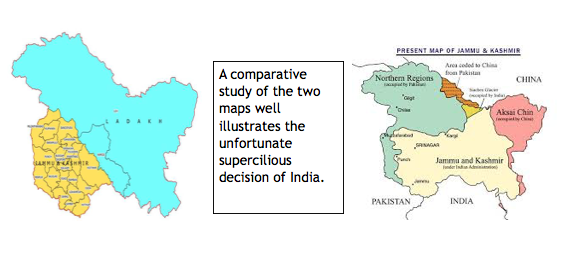
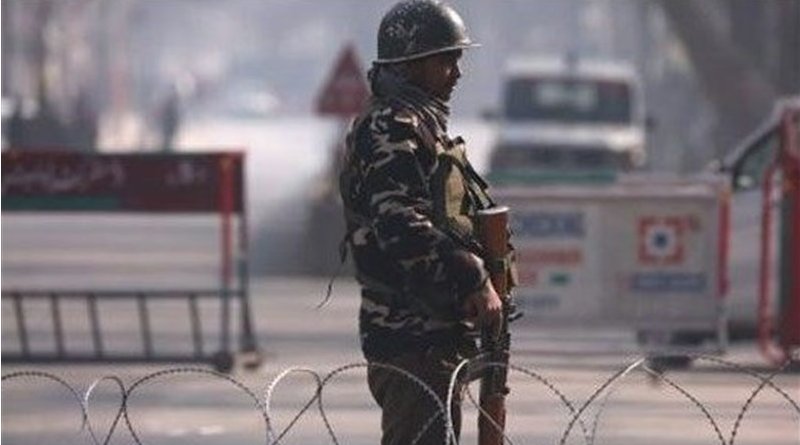
The second Presidential Order on the Reorganization of Jammu & Kashmir by India in 2019 is yet another outlandish decision to challenge the objectives of a peaceful coexistence. It is a call for altering an International Order more conversant to breach the democratic political norms, history and fundamental rights. Kashmiris are once again rebuffed of their demand for self-determination while being locked in an unprecedented brutal curfew entering into more than one hundred days. The desecration is obviously offensive.
Including the areas of Gilgit, Gilgit Wazarat, Chilhas and Tribal Territory of 1947, a part from the remaining areas of Leh and Ladakh districts of 1947 into the Indian Union is a violation of several United Nations Security Council resolutions passed decades ago. The Kargil District was already carved out.
Historically, there were 14 Districts of Jammu & Kashmir at the time of partition, which included Kathua. Jammu. Udhanpur, Reasi, Anantnag, Baramullah, Poonch, Mirpur, Muzaffarabad, Leh and Ladakh, Gigit, Gilgit Wazarat, Chilas and Tribal Territory. The new districts included were Kupwara, Bandipur, Ganderbal, Srinagar, Budgam, Pulwama, Shupian, Kulgam, Rajori, Ramban, Doda, Kishtiwar, Samba and Kargil. The illustrative declaration of Muzaffarabad and Mirpur Khas areas of Azad Kashmir which are under the administrative rule of Pakistan is an untenable denial of the history of the region.
To refresh their memories India needs to remember that at the time when Maharaja Hari Singh signed the controversial Instrument of Accession with India in October 1947, Gilgit was already inflamed with the passions of rebellion against Hindus and Sikhs living in Gilgit. While representing the will of his people, Muzzaffar, the raja orderly in Chilas said:
“The whole of Gilgit Agency is pro-Pakistan … we could never swear allegiance to Hindustan. Apart from religion, the Gilgit Agency is really a part of the NWFP and is therefore a part of Pakistan. If Kashmir remains independent, well and good … .But if the Maharaja through pig headedness and bad advice, political pressure or attractive remunerations accedes to Hindustan, then there will be trouble here!”
This was sensed by the British Administrator William Brown as well and decided to overthrow the then Governor Ghansara Singh in a bloodless coup d’etat in November 1947 and a provisional government was established by the locals of Gilgit. Raja Shah Rais was appointed as the president and Mirza Hassan Khan as the Commander-in-Chief. Pakistani political agent took over the region, once Khan Abdul Qayyum received a telegraph from Brown on November 16, 1947.
By May1948, the Gilgit Scouts had already taken over Baltistan, Ladakh and Skardu as well. Indian reinforcements were blocked at Dras and Kargil which helped them cut off Indian communications to Leh in Ladakh. However, Kargil was recaptured by them in autumn 1948 but Baltistan remained in control of Pakistan, after which India itself took the issue to the UN.
The current remapping of the region of Jammu & Kashmir is nonetheless not only a snub of facts but also adding into already destabilising factors in the region. The Pakistani parts of Kashmir to the north and west of the cease-fire line established at the end of the Indo-Pakistani War of 1947, or the Line of Control as it later came to be called, were divided into the Northern Areas in the north and the Pakistani state of Azad Kashmir in the south. The name “Northern Areas” was first used by the United Nations to refer to the northern areas of Kashmir. Pakistan has declared that “no step by India could change the disputed status of Jammu and Kashmir as recognised by the United Nations”, and has pledged time and again that it will continue to support the just struggle of the Kashmiris.

In an attempt to rewind the India of antiquity or revitalize the Indian Civilization lost in the international order of nation-states in the post WWI era, Narendra Modi’s arrogant Hindutva regime is non-realistic. The current attempt is a follow up of the Geospatial Information Regulation Bill (GIRB) passed by the Indian ministry of Home Affairs on May4, 2016, during his earlier tenure of rule on India.
The Bill was meant to regulate the acquisition, dissemination, publication and distribution of geospatial information of India. It restricted the addition or creation of any information related to geospatial imagery, data acquisition through space or aerial platforms such as satellites, aircrafts, airships, balloons or unmanned aerial vehicles without the permission of the government of India.
The Bill also made its violation indictable in contravention of the section 4 with a fine ranging from Rs. 1 crore to 100 crores or imprisonment for a period of up to seven years. The draft resolution had also decided to set up an Apex Committee, A Security Vetting Authority and an Enforcement and Appellent authority to only allow the distribution of maps considered right by the Indian government. It was deceptively declared to ensure the security, sovereignty and integrity of the state of India with impact on all who may or may not agree with the Bill defining the geographical boundaries of India. The spokesman of the Indian External Affairs Ministry Vikas Swarup once reiterated that the state of Jammu & Kashmir was an “integral part of India” and the GIRB was an “entirely internal legislative matter of India.”
Assaulting the international political system, human dignity, basic liberties and perpetual boundary disputes by the Indian offensive posture have added to the stressed political environment of the region. In case of the failure of the domestic proceedings to address human concerns, it becomes mandatory for the world community to ensure the respect of the world peace. History records that after the WWII, there had been 14 out of 21 major inter-state wars on territorial conflicts. Global history of cartography has always been closely linked. Situating the “geobody,” along with altering the archival documents by the nationalist regime of Modi largely emboldened by the Western powers for their own strategic and economic preferences, is a teasing question on the UN partiality. The history of border violations or failed negotiations over an issue increases the likelihood of armed conflict and non-binding management.
*Shamsa Nawaz is working as a Senior Research Associate/ Editor at Strategic Vision Institute, Islamabad.


More rant from Pakistan. Telling a lie 1000 times does not become truth.
The partition of India was a colossal mistake. Nothing however can be done about it. Jinnah’s vision of a secular Muslim majority Pakistan was replaced by Zia’s fundamentalist Pakistan and is now fast becoming a terrorist haven leading to a failed State. Whatever arguments are made on Kashmir, the majority of it as well as Ladakh will remain with India. Pakistan failed to get support for its claim in any of the Arab countries. So forget Kashmir and both India and Pakistan should concentrate on economic development.