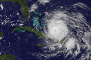
Irene Becomes Major Hurricane, Captured On GOES-13 Satellite Video
When a satellite can see a hurricane’s eye clearly from space, that’s an indication of a strong tropical cyclone and the GOES-13 satellite saw just that in Hurricane Irene this morning as she became a major hurricane. An animation of GOES-13 satellite imagery released from NASA today shows Irene’s transition into a powerhouse and pinpointed when her eye became visible from space.
Hurricane Irene reached Category 3 status this morning, the threshold for a major hurricane on the Saffir-Simpson scale that measures hurricane intensity.

The Geostationary Operational Environmental Satellite called GOES-13 provides continuous visible and infrared imagery of the eastern U.S. and Atlantic Ocean basin from its position in space. GOES satellites are operated by NOAA, and the NASA GOES Project located at NASA’s Goddard Space Flight Center in Greenbelt, Md. creates images and compiled them into the video of the storm as it developed from June 27 to June 28.
The animation includes sped up infrared and visible frames of data from the GOES-13 satellite and is squeezed down to 36 seconds. The movie shows satellite imagery that was captured in 15 minute intervals from August 22 at 8:40 a.m. EDT (1240 UTC) until August 24 at 8:40 a.m. EDT shows Irene moving over Puerto Rico, Hispaniola and toward the southeastern.
Irene became a major hurricane at 8 a.m. EDT today, August 24, 2011 as it headed toward the Crooked and Acklins Islands in the Bahamas. Irene’s maximum sustained winds had increased to 115 mph (186 kmh) making Category three status. Additional strengthening is forecast by the National Hurricane Center (NHC). Category three hurricanes can cause “devastating damage” according to the NHC’s webpage: http://www.nhc.noaa.gov/sshws.shtml.
Irene is located about 55 miles southeast of Acklins Island, Bahamas, near 21.9 North and 73.3 West. It was moving to the west-northwest at 9 mph (15 kmh) and had a minimum central pressure near 957 millibars.
A hurricane warning is in effect for the southeastern, central and northwestern Bahamas, and a tropical storm warning is in effect for the Turks and Caicos Islands. An unofficial reporting station at Pine Cay, located in the Caicos Islands reported a wind gust to 65 mph (105 kmh) earlier today.
Rainfall amount across Hispaniola and Puerto Rico will be between 1 and 3 inches as Irene pushes away. However, isolated maximum storm total amounts of 15 inches are possible with flash floods and mud slides in areas of steep terrain. In the Bahamas, Turks and Caicos islands high rainfall totals are forecast by NHC of between 6 to 12 inches are expected.
The NHC warns that “an extremely dangerous storm surge will raise water levels by as much as 7 to 11 feet above normal tide levels over the central and northwestern Bahamas and by as much as 5 to 8 feet above normal tide levels over the southeastern Bahamas and the Turks and Caicos islands.”
Hurricane Irene is a large storm that has continued to grow over the last several days as it has strengthened. Tropical storm-force winds extend out to 205 miles from its center, making Irene about 410 miles in diameter! Hurricane force-winds extend out to 40 miles, or 80 miles in diameter.
The NHC’s current forecast track for Hurricane Irene takes the storm to a landfall in eastern North Carolina as a major hurricane on Saturday, August 27. The NASA GOES Project will continue to provide imagery and animations from the GOES-13 satellite daily as Irene nears the U.S.
