NASA Sees Triple Tropical Trouble in Northwestern Pacific
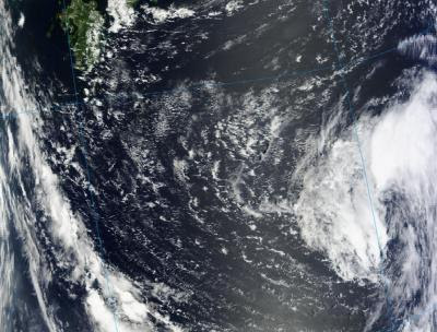
NASA’s Aqua satellite captured an image of a very busy northwestern Pacific Ocean where three tropical cyclones are active. Tropical Storms Damrey and Saola are dissipating in China, while Tropical depression Haikui developed on August 3, 2012.
NASA’s Aqua satellite passed over the northwestern Pacific Ocean on August 3 at 0453 UTC (12:53 a.m. EDT) and the Atmospheric Infrared Sounder (AIRS) instrument captured all three tropical cyclones in one image. AIRS observes in infrared light, which basically provides temperature information. In respect to tropical cyclones, the higher the thunderstorms (they’re made up of hundreds of thunderstorms), the colder the clouds and stronger the thunderstorms.

AIRS data showed that cloud top temperatures in Damrey and Saola were warming, while Haikui had a large area of cooling cloud top temperatures. As Damrey made landfall north of Shanghai, China, it was cut off from its power source of warm water, so there was less water vapor to feed into the storm, and the uplift of air weakened (stronger uplift creates clouds and thunderstorms), so the cloud heights fell, and the cloud top temperatures warmed. The same thing occurred in Tropical Storm Saola when it made landfall south of Shanghai. Both storms appeared as tight, rounded areas over land in the AIRS image.
The AIRS image caught the western edge of Tropical Depression Haikui, and it showed a large area of very cold cloud top temperatures, indicating a lot of strength in uplift and strong, high thunderstorms. A good portion of Haikui’s cloud top temperatures were as cold as -63 Fahrenheit (-52 Celsius). Those strong storms are indicative of areas where heavy rain is falling. Satellite imagery revealed that the low-level circulation center is partly exposed. There is also a fragmented, banding of thunderstorms wrapping from the northeast quadrant into the northwest quadrant of the storm.
The final warning for Tropical Storm Damrey was issued on August 2 at 2100 UTC, or 5 p.m. EDT. At that time, Damrey had already made landfall north of Shanghai, China, and was about 325 miles (374 miles/602 km) south-southeast of Beijing near 35.0 North latitude and 119.2 East longitude. Damrey’s winds were still near 55 knots (63.2 mph/102 kmh) after landfall, but weakening as it moved in a west-northwest direction. Damrey’s remnants are expected to dissipate today, August 3.
The final warning on Tropical Storm Saola came today, August 3 at 0300 UTC (Aug. 2 at 11 p.m. EDT) from the Joint Typhoon Warning Center. Saola had already made landfall south of Shanghai and north of Fuzhou, China, and is dissipating inland. At that time, it was centered near 27.0 North latitude and 119.3 East longitude. Saola’s maximum sustained winds were less than Damrey’s and near 35 knots (40 mph/65 kmh). Saola was also moving faster than Damrey (located to the north) at 14 knots (16 mph/26 kmh). Saola is expected to dissipate today or on August 4.
Out over the open waters of the northwestern Pacific Ocean, newborn Tropical Depression Haikui was getting organized. On August 3 at 1500 UTC (11 a.m. EDT) Haikui’s maximum sustained winds were near 30 knots 34.5 mph/55.5 kmh). It was located 580 nautical miles east of Kadena Air Base, Okinawa, Japan, and is moving to the west-northwest at 13 knots (~15 mph/24 kmh). The Joint Typhoon Warning Center forecast calls for Haikui to pass just north of Kadena Air Base on August 5 and slowly intensify.
