
The Eastern Mediterranean Issue And Turkey’s Blue Homeland Doctrine – Analysis
Turkey is a country surrounded by three major seas: the Black Sea, the Aegean Sea, and the Mediterranean. Last year, Turkey and Greece came face to face in the Eastern Mediterranean, in which Turkey has a 1,870 km coastline while Greece’s coast length is 167 km. The reason for the dispute was Turkey’s initiation of a seismic survey to find gas in the Eastern Mediterranean waters. The world is closely monitoring what steps Greece and Turkey will take in the days coming by.
The Importance of the Eastern Mediterranean
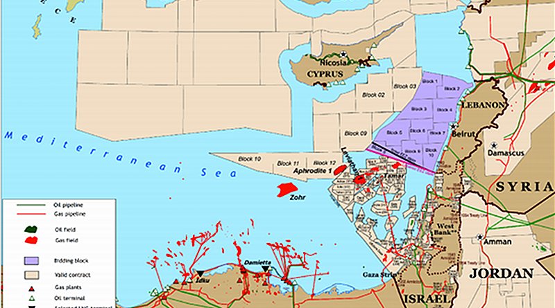
The Eastern Mediterranean is surrounded by the coastlines of Italy, Slovenia, Croatia, Bosnia-Herzegovina, Montenegro, Albania, Greece, Turkey, Syria, Lebanon, Israel, Egypt, Libya, and Tunisia.
From a historical perspective, this region has been at the target of the first civilizations. Regional countries such as Egypt, Mesopotamia, and Anatolia possessed the most fertile soils in the world. Therefore, the region has been exposed to important wars in different stages of history to dominate these fertile soils and to take control of the world trade by land and sea. This ambition turned the region into the most important and most crowded centers of the world.¹
Taking the famous saying “Who rules the seas, rules the world” of the famous Turkish Chief Admiral Hayrettin Barbarossa Pasha as their motto, the Ottomans initiated in being a maritime nation since the end of the 15th century.²
During the reign of Suleiman the Magnificent, the Ottomans became the dominant power of almost the complete Mediterranean in the 16th century. The Ottoman navy had been the dominant power both in the Black Sea and the Mediterranean from the 16th century till the middle of the 18th. Their superiority in the East Mediterranean continued till the middle of the 19th century and then the borders shrank to the Anatolian shores as the Ottomans lost their interest in maritime.³
The importance of the Eastern Mediterranean, which had been the crucial point in the world sea trade, had been increased with the official opening of the Suez Canal in November 1869. The 193.30 km-long Suez Canal is located in Egypt and connects the Mediterranean Sea with the Red Sea. Transiting via the Suez Canal, the journey from Europe to the Near east cuts off 7,000 kilometers compared to the one made through the South Atlantic and southern Indian oceans.⁴
The “Blue Homeland” Doctrine
Greco-Turkish maritime conflict flared up from time to time as we witnessed in the Kardak Crisis in January 1996. The cause of this crisis was that the Turkish-owned ship Figen Akat ran aground on an island called Kardak. The Kardak Crisis, which brought Turkey and Greece to the brink of war, was resolved in one month.
Now, the dispute has transformed into a new phase with the hydrocarbon deposit discovery in the Mediterranean. Admiral Cem Gürdeniz gave rise to a new concept called the “Blue Homeland,” which came to be a state doctrine in 2016 by Admiral Cihat Yaycı. It was crucial for the Turkish Republic to defend its territorial sea and its land.
According to this doctrine, the Blue Homeland map that was drawn includes 462,000 km². This map outlines the continental shelf, determines the EEZ (exclusive economic zone), and draws the borderlines showing how far we have borders and what rights and authorities we have in the surrounding seas. Turkey’s legal struggle of its exclusive rights over all living and non-living resources in the area is called the Blue Homeland Struggle.⁵
In 2019, the Turkish navy carried out the biggest joint exercise that included a wide range of ships and aircraft simultaneously in three seas surrounding Turkey. This exercise was called “Blue Homeland” referencing the importance of the doctrine.
On November 27, 2019, Turkey signed the Memorandum of Understanding on the Delimitation of Maritime Jurisdictions with Libya drawing Turkey’s western border in the Eastern Mediterranean. This agreement approved by the UN gave Turkey a serious advantage in the region.
What is the recent East Mediterranean issue?
Oruç Reis started to make seismic research in the Eastern Mediterranean in 2020. Thereupon, Greece to this activity with the claim that Turkey was violating the rights over a Greek island called Meis.
Following Turkey’s delimitation memorandum with Libya, which Greece deemed invalid, Greece declared that it considers the regions including the south of Crete, Karpathos, and Rhodes islands as part of its continental shelf. Greece embraces all the water between the islands as its internal water and that each island has its own EEZ. Arguing that the Turkish-Libyan agreement is not under international law, Greece demanded that Turkey terminate its hydrocarbon research in the region.
Greece sent warships to the region and hastily signed an agreement with Egypt. He had previously signed a similar agreement with Italy. The Turkish Ministry of Foreign Affairs nullified this Egyptian-Greek maritime jurisdiction delimitation agreement since it is not a legal agreement. The only reason for signing such an agreement is to leave aside the memorandum of Libya and Turkey. Then UAE and Israel also signed an agreement and showed their support to Greece.
After that, Turkey announced NAVTEXs one after another from Oruç Reis sent to the field by the Turkish Ministry of Energy and Natural Resources in the Eastern Mediterranean.
For those unfamiliar with the term NAVTEX, it is an acronym for navigational telex (navigational text messages) and a device used on-board the vessels to automatically provide short-range Maritime Safety Information in coastal waters. NAVTEX is binding on the declared and announced countries.
Turkey decided to take a break from its activity for a few weeks to clear the atmosphere as Germany intervened in the dispute. But due to Greece’s failure to agree, he declared a new NAVTEX informing the places the ship would be able to research.
Greece did not give up on the counter-attack and finally asked the European Union member states to impose sanctions for Turkey’s activity in the Eastern Mediterranean. Even though the EU prepared a list of possible sanctions against Turkey in August 2020, no sanctions were exposed until now.
While Oruç Reis was expected to stop on September 1, 2020, it was extended until September 11 with a final NAVTEX. This conflict was considered the most dangerous tension in recent years. It was a threat not only to the intervening two countries but to the entire world.
The leaders of Turkey and Greece had a positive and productive meeting in Brussels following the NATO Summit on 14 June 2021. According to the statement of Turkey’s President Erdoğan during the press meeting the same day in Brussels, the two leaders agreed to contact each other via their direct phone line and solve the issue among themselves without involving other countries if a new problem arises in the future.
Why Greece-Egypt agreement is not legally valid?
The Crete, Karpathos, Kassos, Rhodes, and Meis line, on which this agreement is based, does not give Greece the right to a continental shelf because Greece is not an archipelagic state as opposed to its claims. After all, only 17% of the country’s surface area comprises islands, islets, and cliffs; and these islands are within 200 miles of the Greek mainland. These types of islands are given a continental shelf as much as they are given territorial waters.
According to Article 46 of the UNCLOS (United Nations Convention on the Law of the Sea), the archipelagic state means a State constituted wholly by one or more archipelagos and may include other islands. In UNCLOS, in the decisions of the International Court of Justice and the Arbitral Tribunal, no principle or decision can make Greece an “Archipelagic State”.⁶
The Seville Map and the EU
The basis of Greece’s opposition to Turkey’s existence in the Eastern Mediterranean is based on the Seville map. It got this name because it was prepared in the early 2000s by academics Juan Luis Suárez de Vivero and Juan Carlos Rodríguez Mateos from the University of Seville. According to the claim of the map, the Greek continental shelf, which starts from Meis Island, descends southward to the middle of the Mediterranean. It draws the continental shelf of Greece according to the borders of the Greek islands, no matter how close they are to Turkey. The map shows only a small area in the Gulf of Antalya as Turkey’s maritime jurisdiction.
Turkey, on the other hand, says that this map unfairly violates its rights and emphasizes that the creation of a continental shelf area of 40 thousand square kilometers by an island (Meis) with a surface area of 10 square kilometers, 2 kilometers from Anatolia and 580 kilometers from the Greek mainland, is not valid according to the international law.⁷
Although the EU states that this map has no legal validity and denies their affiliation, they shape all their maritime policies, including fisheries, accordingly. Every objection to Turkey’s seismic surveys in the Eastern Mediterranean is also based on this map.
The future is in the seas
As admirals, Cem Gürdeniz and Cihat Yaycı, who shaped the Blue Homeland doctrine, emphasized the future of the world is in the seas. We can find the energy resources depleting day by day on land in the waters. We have received the good news of this with the gas resources that Turkey has recently found in the Black Sea.
Thanks to the Blue Homeland doctrine, Turkey has become more conscious of the importance of the sea and its resources and will defend every drop of the water it possesses according to the authority given by international law, in the same way as it protects every bit of its land. And it will continue to defend all the authorities it is entitled to.
*About the author: Ece Uyguç is an economist, and a certified English-Turkish translator and opinion writer.
Source: This article was published at Medium.com
References:
- Şenay Kaya, Uluslararası Deniz Hukuku Kapsamında Doğu Akdeniz Sorunları (Eastern Mediterranean Problems under International Law of the Sea), Post Graduate Thesis (Ankara: Ankara University, 2007), 5.
- Ali Kurumahmut, Ege’de Temel Sorun: Egemenliği Tartışmalı Adalar(The Main Problem in the Aegean Islands: Controversial Dominion), (İstanbul: Turkish History Society Publications, 1998), 35.
- Ali Kurumahmut, Ege’de Temel Sorun: Egemenliği Tartışmalı Adalar (The Main Problem in the Aegean Islands: Controversial Dominion), (İstanbul: Turkish History Society Publications, 1998), p. 8.
- Mohit Kaushik, “The Suez Canal: A Man-Made Marvel Connecting the Mediterranean and Red Sea,” Marine Insight, December 19, 2020.
- Tevfik Kadan, “The formulation of the Blue Homeland doctrine,” Belt & Road Initiative Quarterly (2020/2021), 2(1), 36–50.
- Tevfik Kadan, “The formulation of the Blue Homeland doctrine,” Belt & Road Initiative Quarterly (2020/2021), 2(1), 36–50.
- Sözcü Newspaper, “Sevilla haritası nedir, ne anlama geliyor?” (What is Sevilla map, what does it mean?), September 22, 2020.