
India-Bangladesh Delimitation Of EEZ: Utilizing The UN Tribunal – Analysis
By FSI
By Jemimah Joanne C. Villaruel*
The simmering territorial and maritime dispute in the South China Sea seems poised to lengthen and grow even more complex with ASEAN states such as the Philippines and Vietnam trading barbs with China over the conflict. In fact, the Philippines-China maritime dispute has now reached a pivotal point as the arbitration case submitted by the Philippines to the UN is currently underway. Meanwhile, the US and Japan have criticized China’s reclamation activities and in turn, China has accused the US of meddling in the disputes and militarizing the area. While the nexus of maritime security issues and its corresponding actions in ASEAN region grows convoluted, the recent resolution of the maritime boundary dispute between India and Bangladesh in the Indian Ocean is a welcome development.
While all eyes are fixed on an increasingly volatile South China Sea, the Indian Ocean is also fast becoming a locus for strategic and maritime competition between major and rising powers. As the world’s third largest ocean, the Indian Ocean covers a vast area of approximately 66,000 kilometers of coastlines and serves as one of the world’s major sea lines of communication linking the Middle East, Africa, and East Asia as a critical trade route for oil exports from Gulf nations.
Bangladesh, for its part, has limited natural resources. With its naturally concave coastlines, Bangladesh’s proposed maritime zones overlaps with those of India and Myanmar, presenting complications in exploring and exploiting its maritime domain.
An island in the Bay of Bengal
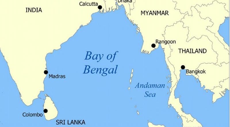
The case known as the Bay of Bengal Maritime Boundary Arbitration between India and Bangladesh has undergone a long and arduous process of negotiations starting on 8 October 2009 when Bangladesh lodged an arbitration case concerning the delimitation of its maritime boundary with India pursuant to Article 287 and Annex VII, Article 1 of the United Nations Convention on the Law of the Sea (UNCLOS). The arbitral tribunal ruled on the location of the land boundary terminus, delimitation of the territorial sea, exclusive economic zone, and the continental shelf within and beyond 200 nautical miles between the two states.
The maritime dispute between India and Bangladesh began in the 1970s when a small island named New Moore in India, and South Talpatti in Bangladesh, first emerged in the mouth of the Hariabhanga River in the Bay of Bengal, which serves as a river border between India and Bangladesh. Both countries immediately claimed sovereignty on the island. Although the island has since disappeared, the maritime dispute remained unresolved for many years until the UN tribunal handed down its decision in 2014.
Myanmar and India, situated on either side of Bangladesh, favored a maritime delimitation based on equidistance. But Bangladesh countered that due to its natural and unstable concave coastline, the equidistance method would be disadvantageous and result in the country being zone-locked. Utilizing the equidistance method would also restrict Bangladesh’s exclusive economic zone (EEZ) to 180-190 nautical miles instead of the 200 nautical miles provided by UNCLOS, which would deprive its entitlement to an outer continental shelf.
UN Decision
The arbitral tribunal decided that using equidistance to arrive at an impartial solution was the appropriate method in delimiting the EEZ and continental shelf of India and Bangladesh. A provisional equidistance line was then constructed by the Tribunal which would serve as a basis for measuring the EEZ and continental shelf of both countries. The Tribunal acknowledged that due to the concavity of the coastline of Bangladesh, the provisional equidistance line necessitated an adjustment in favor of Bangladesh. As a final step to the delimitation, the Tribunal also conducted a Disproportionality Test to ensure that both countries were allocatedwith a maritime space proportional to their respective coasts. The delimitation by the Tribunal, however, gave rise to a ‘gray area’ located beyond 200 M of Bangladesh’s coast but within 200 M of the coast of India. To address any potential dispute in undertak-ing maritime activities in this area, the Tribunal decided that Bangladesh has sovereign rights to explore the continental shelf, sea-bed and subsoil such as for oil and gas, while India has sovereign rights to its waters which would encompass fishing activities.
Thus, on 7 July 2014, the UN tribunal handed down its long-awaited decision on the delineation of maritime boundaries between the two countries awarding 19,467 sq. km of the 25,602 sq. km sea area of the Bay of Bengal to Bangladesh. Although the bulk of Bangladesh’s claim to the continental shelf was not admitted by the Tribunal, it was still able to gain an outlet to the extended con-tinental shelf allowing it to explore oil and gas in the Bay of Bengal. The award was also positively received by India as it was able to keep a majority of its claimed maritime area and gain control over the disputed waters surrounding the now submerged New Moore Island.
The role of UNCLOS
While the maritime dispute between India and Bangladesh was positively concluded, it was beset with its own set of challenges over roughly four decades. However, there is no doubt that the peaceful resolution of these decades-long maritime disputes will yield tremendous benefits for both countries, allowing them to freely explore and exploit the marine resources of their respective territories, enhance their bilateral relations, and contribute in the preservation of peace and security in the region.
In comparison, the Philippine maritime arbitration case with China is confounded by political and legal challenges. Part of what makes the arbitration case so complex and contentious is that the jurisdiction and legitimacy of the UN Tribunal itself to implement and enforce the provisions of the Convention is called into question by China. The Philippines and China are both signatories to the Convention, unfortunately, China is unwilling to submit to the processes of the Tribunal. This contrasts with the case of India and Bangladesh that are both signatories and have consented to undergo third party arbitration to resolve their maritime dispute. This illustrates that some Asian countries view arbitration and other international legal processes as an acceptable form of resolving differences.
The arbitration case between India and Bangladesh is remarkable as it has shown that arbitration is an internationally recognized, friendly, rules-based and peaceful method of resolving maritime disputes. Respect for international law, particularly UNCLOS, by countries big or small is thus crucial in promoting peace and stability in the seas. Despite India being a greater power, it did not use its significant naval capabilities to forcefully assert its claims. Both countries allowed the rule of law to prevail.
As Philippine Foreign Affairs Secretary Albert Del Rosario stated in his speech before the UN Tribunal in July 2015, international law serves as a great equalizer among states. Recognition and respect for these rules serve an important purpose – to ensure that fairness is served and states act within the ambit of internationally set laws and conventions. The Philippines has always reiterated its call for a peaceful resolution to the maritime disputes in the region. With its maritime arbitration currently underway, and with mounting pressure from China to withdraw its legal case, the Philippines can draw inspiration from the positive outcome of the India-Bangladesh maritime case. This ultimately serves as an example of state best practice in managing maritime disputes through an arbitral tribunal.
About the author:
*Jemimah Joanne C. Villaruel is a Foreign Affairs Research Specialist with the Center for International Relations and Strategic Studies of the Foreign Service Institute. Ms. Villaruel can be reached at [email protected].
Source:
This article was published by FSI. The views expressed in this publication are of the authors alone and do not reflect the official position of the Foreign Service Institute, the Department of Foreign Affairs and the Government of the Philippines.