
Amazonian State Runs Dry As Half Its Surface Water Area Lost – Analysis
By Mongabay
By Amanda Magnani
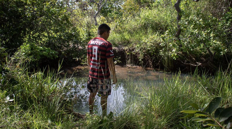
During the rainy season, the sunlight that passes through the leaves of the mirixi and jenipapo trees paints golden patterns in the blue-green water of the creek that runs through the Morcego Indigenous community.
“This is where my younger brother learned how to swim as a kid,” Leirejane Nagelo, the tuxaua, or chief, of the community, tells Mongabay. Back then, the creek’s level was high enough. Nowadays, however, if her 25-year-old brother, Daniel Nagelo, were to step into the water, it would barely reach his waist — even during the wet season here in the Amazon.
Morcego Creek, named after the community, runs behind Leirejane’s house, where she lives with her husband and six children, all under the age of 16. It’s concealed beneath the shade of bushes on a 100-meter (330-foot) walk under mango trees and over a tall grass field.
Morcego is one of the three communities located inside the Serra da Moça Indigenous Territory, in the Brazilian state of Roraima, and its creek is the only natural water source in the 11,417-hectare (28,212-acre) territory. Officially protected by presidential decree in 1991, Serra da Moça is home to nearly 750 people, according to a 2022 census.
Like most Indigenous lands in the state, Serra da Moça had its boundaries demarcated in what’s known as an island format. Rather than being composed of a large, contiguous swath of territory, it’s small and encompasses only a few communities, separated from one another and surrounded by monoculture plantations.
“Island demarcated territories face severe problems due to the scarcity of natural resources,” Sineia do Vale, national coordinator for Brazil’s Indigenous Committee on Climate Change, tells Mongabay. “Because most of the water springs are located beyond the boundaries of the lands, outside the domain of Indigenous communities, we have no governance over what is done to creeks and streams,” she adds.
For the residents of Morcego, that’s meant decades of being unable to protect their main water sources from silting and contamination.
“Back in the 1990s, when I was a student, we used to collect the water from the creek for our everyday use,” Luís Fagner da Silva Oliveira, an Indigenous teacher and farmer, tells Mongabay during a visit to the tuxaua’s house to drop off some watermelons and tomatoes from his orchard. “We would carry the water to be used for cooking at school, and we would also wash ourselves in the stream,” he adds.
Lately, however, the waterway that was once so dependable has dried out in the summer months.
Morcego Creek embodies a reality afflicting the world’s largest rainforest. In early October, images of the historic drought currently ravaging the Amazon shocked the world. Ships were stranded in once navigable rivers, dozens of dolphins were found dead, and more than 500,000 people were affected.
But that was just the latest episode in a crisis that has been underway for decades.
For the past 20 years, the nine countries that make up the Amazon Basin have seen drastic reductions in their total water surface area. In Brazil alone, home to 12% of the world’s freshwater sources, bodies of water have shrunk in size by 14.5%.
During this period, Roraima was the worst-affected state, having lost 53% of its water area, according to a study published in 2022 by MapBiomas, a collaborative network that produces mapping of land cover and water coverage.
“The Amazon Rainforest is experiencing the driest decade in recorded history,” says Bruno Ferreira, a forestry engineer and researcher at Brazilian conservation nonprofit Imazon, one of the organizations behind the study. “Nine out of the past 10 years were among the driest ever registered,” he adds.
This year, the record-breaking drought, which might still extend until January 2024according to Brazil’s national disaster-monitoring agency, Cemaden, has worried Leirejane and other Indigenous leaders. “Summer arrived early this year, leaving much of our harvest compromised. Water is life — and we are already feeling the consequences of its absence,” the tuxaua says.
From a bad plague to a worse one
Pinpointing the culprit of the water loss in Roraima is a delicate task. The usual suspects, however, are never too far away.
“When we look at the maps of land coverage and use in the state, the surge in new pasture areas harming the native vegetation is exponential,” Ferreira says. When trees and bushes are cleared from the land to create livestock pasture, the soil loses its filtration and storage capacity, he says. “The native vegetation works like a sponge, regulating water surfaces during dry and flood periods.”
Carlos Sander, a geography professor at the Federal University of Roraima (UFRR), says large portions of the state are covered by lakes and swamps, and farmers commonly drain these wetlands. “As a result, water sources that used to be perennial are becoming seasonal or even disappearing for good,” he says.
According to MapBiomas data, between 1985 and 2022, the area destined for agricultural use in Roraima went from roughly 94,000 to 1.135 million hectares (232,300 to 2.805 million acres) of land, an increase of more than 1,100% over a period of less than four decades. “Monocultures didn’t use to be common in our region,” Leirejane recalls. “But the years went by and with them came agribusiness, with all its negative impacts.”
In the early 2000s, Indigenous leaders blamed acacia plantations surrounding protected territories for silting up waterways. “The trees sucked up all the water and drained our streams,” Daniel tells Mongabay. He was just a child at the time, but he remembers the changes to Morcego’s water source as being fast and drastic. “Our territory is small and so are our water sources and springs. They are more easily exhausted,” he says.
Today, after most of the acacia plantations became unprofitable and were abandoned, the dominant monocultures in Roraima are soy and corn. “They replaced a plague with an even worse plague,” Daniel says. “With soy and corn plantations, we face not only water drainage but also the effects of pesticides.”
Walking around the community, Leirejane reaches a barbed wire fence that separates Morcego from one of the many plantations that surround the community. The difference between the Indigenous land and the soy fields is stark. On one side, tall grass fields are spotted with twisted trunk bushes and buriti palm trees, the traditional coverage of lavrado de savanna, as the local vegetation is known. On the other, a single shade of green, homogeneously grown into lanes.
Leirejane points to the nearest side of the fence: “That is where planes used to fly about a year ago, spraying pesticides on the fields. Only a few meters away from our community.”
Since agribusiness arrived in the Murupu region, where the Serra da Moça territory is located, invasions of Indigenous lands have increased; traditional access to forests and lakes where they could fish, hunt and chop timber has been suppressed; and water sources have become contaminated, Leirejane says. “Now, we are basically forced to live a way of life that doesn’t align with our traditional culture,” she says.
However, pesticides aren’t the only threat to the quality and availability of water in the region. “With the advance of illegal mining, especially inside Indigenous territories, we see changes to the course of rivers and mercury pollution,” Ferreira says.
Under Brazil’s previous government, illegal mining in protected lands increased by 90%from previous years. According to MapBiomas, the distance between illegal mining sites and bodies of water in the Amazon had never been as short as in 2022. That same year, studies found elevated levels of mercury in rivers across Roraima. The contamination has gotten so severe that consuming the fish caught in these rivers has become a health hazard.
Water contamination
Over the past decade, Morcego has been one of the most affected regions as the dry seasons have become more intense.
“The Murupu and Baixo Cotingo regions work as our ‘thermometer’ to measure the effects of the hydro crisis, as therein lay the communities which suffer the most from lack of water,” Sineia do Vale tells Mongabay. “In some years, the water wells get so dry you could literally sweep their bottoms.”
Faced with this reality, the Indigenous Council of Roraima (CIR), where Vale serves as the environmental coordinator, has been working alongside communities to find solutions to address the water crisis and its associated problems.
“Over the years, we have been working alongside the women in the communities to tackle access to water and its quality, as well as to find alternatives to keep animal husbandry possible,” Vale says.
Their work began in Murupu following the observation that, during winter months, cases of diarrhea and other diseases increased in the communities. As would later be discovered, one of the main issues was that rainwater runoff was washing contaminants into water wells, the main water source for residents of communities with limited streams.
“A lot of things used to fall into the wells: frogs, insects, little animals,” Leirejane recalls. “But we had to consume this water, as it was the only one we had.”
In response, CIR worked to revitalize the wells and build concrete covers to protect them during the rains. They mobilized the women, who are usually responsible for the community’s daily water management, be it for consumption, household chores, or watering the crops.
Leirejane and her family were the first to be assisted by the project. Some 20 m (66 ft) from her house, halfway to her mother’s home, sits the concrete well, surrounded by tall grass. It takes strength to open the heavy cover. At the bottom, the water reflects the sunlight. An old tin can tied to a rope serves as the bucket.
“Ours was the very first well cover. You can see here that the date of its fabrication is engraved: November 5, 2013,” Leirejane says. “Since then, the quality of our water has greatly increased.”
Roraima’s vulnerabilities
Due to the state’s geographical characteristics, Roraima is particularly vulnerable to droughts. “We have large areas of lavrado, the largest savanna in the Amazon. While this is important for biodiversity, it also makes the region naturally drier and with lower levels of rainfall,” Ciro Campos, a biologist at the Instituto Socioambiental (ISA), a nonprofit that advocates for environmental and Indigenous rights, tells Mongabay.
According to Imazon’s Bruno Ferreira, the lavrado landscape is characterized by swamps and lakes. “However, when you look at the satellite images from the past decades, it is clear that they are disappearing,” he says.
And this year’s El Niño has only exacerbated the problem. Combined with exceptionally high temperatures in the North Tropical Atlantic, it’s set to usher in one of the longest and worst droughts ever recorded in the Amazon.
“Around 50% of the time, the world is under the influence of either El Niño or La Niña,” Sander says. “These events are more common than once believed and can arrive as weak, moderate, or strong. The stronger the El Niño, the worse its impacts. And this is proving to be a very strong one.”
Sander compares what’s happening now with the 2016 El Niño, which caused the worst drought ever recorded in Roraima, leading the state to declare an emergency in 13 of its 15 municipalities.
“There are evils that come for good: before 2016, we experienced a strong El Niño in 2009. The experience forced the government to be ready, and it answered quickly to the crisis,” Sander says.
Whether lessons from the 2016 drought will lead to a prompt response to the 2023 crisis remains to be seen.
Widespread impacts
“Our communities are already suffering from the drought. Schools have no water for the children, there’s no water for animal husbandry, the creeks that have dried up are affecting fishing and food supply,” Vale says. “Water is life, and when it’s lacking, it affects us on many levels, including the social and cultural life of the communities.”
In October, Indigenous communities across Roraima were gathering in assemblies to present their main needs and to figure out how to mitigate the effects of the water crisis. Among the actions are preventive fires carried out by volunteer brigades in partnership with Brazil’s environmental protection agency, IBAMA.
But Indigenous communities aren’t the only ones affected by this year’s extreme drought. Farmers in rural areas of the state have experienced up to 70% crop lossesdue to the lack of rain. For artisanal fishermen, the circumstances are also dire. “Roraima has nearly 5,000 families who rely on fishing, and prolonged droughts have harsh economic impacts on their lives,” Campos says.
In urban areas, particularly in the Roraima state capital, Boa Vista, informal suburban settlements that have long lacked access to water supplies are the first to feel the impacts of the drought. “There is not a robust conversation about urban well-being, especially for the newer neighborhoods, which are removed from the city center,” Campos says.
So far, however, unlike in the neighboring states of Amazonas and Pará, no municipality in Roraima has declared a state of emergency. On the contrary, the state government says there’s no risk of water shortage, and state water utility, CAER, says it’s preparing to collect underground water. CAER has also launched a tender for a contractor to drill 20 artesian wells in Boa Vista and 20 in rural areas. In mid-October, the government launched Operation Safe Summer, which hired 240 brigade membersto work on fire prevention.
Roraima Governor Antonio Denarium, currently in his second term, is a far-right politician and an ally of former president Jair Bolsonaro. Since the arrival of a new president this year, there’s been a shift in the state’s position. “With the changes to the federal government, Roraima started to signal the adoption of better socioenvironmental practices,” Campos says. “So far, however, it remains in the realm of promises.”
Until these promises materialize, communities like Morcego remain in limbo. “We are living the uncertainty of not knowing whether or not our wells will endure until the end of the summer,” Leirejane says.
This article was published by Mongabay