
Sentinel-3A Satellite Continues To Impress
Hot on the heels of its first Earth image and ocean altimetry data, Sentinel-3A has now delivered the first data from its Sea and Land Surface Temperature Radiometer (SLSTR) instrument.
The three instruments on Sentinel-3A are now offering a tantalising glimpse of what’s in store for Copernicus. The latest images, which feature Europe and Antarctica, come from the satellite’s radiometer.
Launched just three weeks ago, the Sentinel-3A satellite carries a suite of cutting-edge instruments to provide systematic measurements of Earth’s oceans, land, ice and atmosphere. This information will feed into numerous Copernicus services to monitor and manage our environment.
The satellite has already delivered impressive first images from its Ocean and Land Colour Instrument and its altimeter, and now the radiometer has revealed its talents.
The Sea and Land Surface Temperature Radiometer, SLSTR, measures the intensity of radiant energy emitted from Earth’s surface. It measures in nine spectral bands including visible and infrared channels.
The instrument will be used to measure the temperature of the land and sea surface. It also includes dedicated channels for measuring fires. This will help to map carbon emissions from burnt biomass and to assess damage and estimate recovery of burned areas.
The first images come from the instrument’s visible channels only, as the thermal infrared channels have yet to be activated.
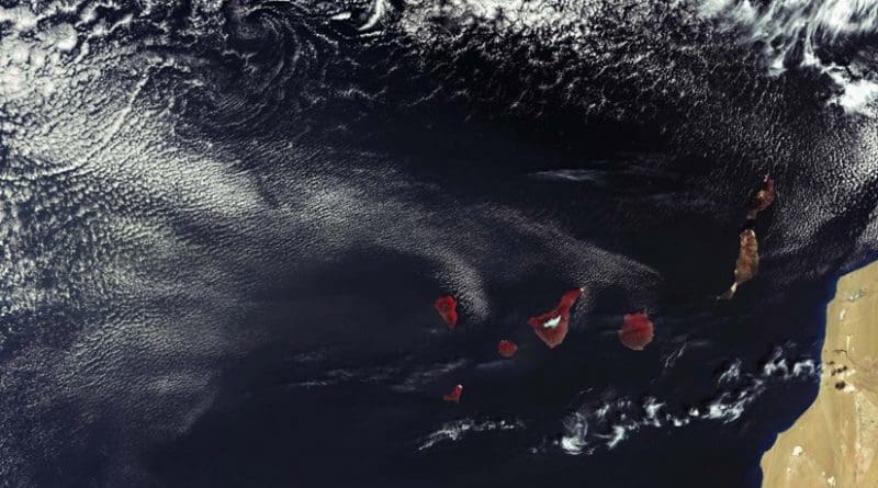
One of the images features the Spanish Canary Islands, the Portuguese island of Madeira and the northwest coast of Africa. This false-colour image shows the vegetated islands in red, in contrast to Western Sahara where there is little vegetation.
The snow-capped peak of Mount Teide on the island of Tenerife is also clearly visible in the image. Both SLSTR and Sentinel-3’s Ocean and Land Colour Instrument, OLCI, will be used to monitor plant health.
ESA’s Sentinel-3 Project Manager, Bruno Berruti, said, “It is very exciting to see all three instruments working well. Of course it is still early days but we are looking to exploiting their full potential and use them together.
“For example, by using data from SLSTR and OLCI we will be able to create what we call synergy products that help us understand the state of the vegetation better.”
Another of the images from its visible channels shows a long crack running through the ice shelf to the east of the Antarctic Peninsula.
The crack is about 2 km wide, but widens to 4 km or more in some places. There are also finer cracks and structures visible in the ice shelf. Structure in the cloud, cloud shadows and details of the land emerging from the ice can also be seen.
An additional false-colour image, captured on 2 March, features a large part of Europe, demonstrating the instrument’s 1400 km-wide swath. It also shows vegetated areas in red as well as storm Jake over the UK which was in force at the time.
EUMETSAT Ocean Remote Sensing Scientist, Anne O’Carroll, said, “These first images are very exciting and show the potential of this innovative new instrument, which is the most advanced of its kind and eagerly awaited by the ocean science community.
“What’s new about the SLSTR is that it records a double view of its path as it orbits Earth, which means that we get more accurate measurements of the temperature of the ocean surface. These measurements are crucial for operational weather and ocean forecasting, to follow climate cycles such as El Niño and to monitor changes in Earth’s climate.”
The thermal channels will be working in a few weeks but this latest Copernicus Sentinel has already impressed with its very first images – which will improve further as operators spend the next five months fine-tuning and commissioning the satellite for operations.