
Pakistan Faces Another High Risk In 2023 – OpEd
The first month of Pakistan’s monsoon season is not even over yet and unusually heavy rainfall has already wreaked havoc across the country. One hundred deaths are attributed to monsoon-related incidents and overflow of rivers in Punjab have displaced 15,000 villagers. Most recently, a strong downpour in the capital Islamabad caused a wall to fall on construction workers sleeping in tents next to it, instantly killing eleven of them.
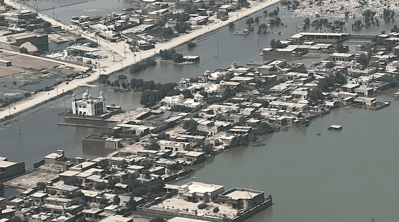
Because Pakistan’s summer monsoon always peaks in late July and August, rainfall and river flow is very likely to increase in the coming weeks. But just how severe could it get? Major floods are already occurring just across the border in northwest India. Floods are the most common of natural hazards in Pakistan. Just last year, Pakistan experienced the biggest flooding in its history, which displaced 30 million people, exceeding the previous worst flooding in 2010. The same floods of 2023 also destroyed a lot of hydraulic infrastructure and left the nation and its people extremely vulnerable to another flood. In the run-up to that disaster, I wrote in my July 17th, 2022 Eurasia Review piece the prediction that “One of the Biggest Natural Disasters of our Times may be About to Strike Pakistan”.
This year, there are again signs pointing to this being repeated. One reason to believe otherwise is that both 2022 and 2010 were significant La Nina years, whereas La Nina ended months ago and an El Nino is currently brewing. While La Nina, which is when trade winds intensify and drag warm surface water in the Pacific Ocean to the west, tends to increase the strength of the Asian monsoon and therefore the chances of floods in Pakistan, El Nino does the opposite, weakening the trade winds and causing water piled up in the west to spread out across the Pacific. Pakistan usually receives less rainfall in an El Nino year.
However, this is already not the case. The nation has been consistently drenched since June 25, slightly before usual start of the monsoon season. And further heavy rains are predicted. We must also note the unusual circumstances attending the current El Nino. It started immediately after a powerful and unusually long-lasting La Nina. Because La Nina transfers heat from the atmosphere into the ocean and El Nino releases it, 2023’s El Nino is essentially on course to release three years’ worth of heat into the atmosphere, and we are already feeling it. Global air temperatures are spiking, which in turn are heating up ocean surface waters globally. Since spring 2023, sea surface temperatures in the northern Indian Ocean, the source of Pakistan’s monsoon, have been extremely high, feeding more moisture into the monsoon system. And hot weather is likely to affect the northern mountains of South Asia, enhancing glacial and snowmelt that feeds Pakistan’s river systems. These same circumstances were also behind Pakistan’s mega-floods in 2010 and 2022.
If an extreme flood event were to strike Pakistan this summer, it would run contrary to the normal patterns of El Nino’s effects on global weather. But that pattern is already expected to be averted one other way. During an El Nino period, hurricane activity in the Atlantic Ocean is usually muted. But this year, meteorological agencies like NOAA predict an about-average hurricane season because of record-high sea surface temperatures in the Atlantic Ocean, warm enough to counteract the effects of the hurricane-shredding wind currents produced by El Nino. We may expect, similarly, that the warmth in the North Indian Ocean has the ability to counteract the usual effects of El Nino for South Asia.
One thing we have to realize, though, is that the temperature of the Indian Ocean is a double-edged sword for the monsoon that originates from it. Monsoon rainfall comes from evaporation in the North Indian Ocean, and the warmer this ocean is, the more evaporation happens. But the monsoon winds that deliver rainfall to South Asia are driven by the temperature differential between land and sea. When summer in the Northern Hemisphere arrives, the land of the Indian Subcontinent heats up much faster than the water of the Indian Ocean. This causes the air directly above the Subcontinent to rise up into the atmosphere, and moisture-packed air over the ocean rushes in to take its place, while the mountain ranges encircling the Subcontinent prevent the moisture from traveling any further. This air then also rises up into the atmosphere, both by heating and by running into the mountains, and it subsequently cools down and releases its moisture in the form of rain. If the North Indian Ocean is warmer than usual, it may have the effect of weakening this monsoon circulation system, because the temperature difference between sea and land is reduced, so all that extra moisture does not go very far.
We can look at this as a safeguard built into the monsoon, a way this powerful weather system can regulate itself. When more moisture evaporates into the air, less of it is delivered to South Asia, and when less moisture evaporates, more of it is delivered. There are countless homeostatic features like this that are part of Earth’s hydrosphere. For example, when the Sun shines down intensely on Earth’s surface and warms it up, it results in water evaporating and ascending into high altitudes, where it condenses into clouds and rain that counter the Sun’s warming effect. This is why the equatorial belt, the part of Earth most exposed to the Sun, is not actually scorching hot, because it is also the cloudiest and rainiest part of Earth. It is also why there is little danger global warming will make Ecuador and Indonesia too hot for humans to live.
There are two possible ways the South Asian monsoon’s self-regulation can fail. One is if the temperature of the Subcontinent is above-normal along with the temperature of the ocean, so the temperature differential is maintained while extra moisture still gets to be pumped into the air. Indeed, this may have been a factor in Pakistan’s 2022 floods. In the spring and early summer of that year, there was a record outbreak of heat across India and Pakistan, which may have also extended to the Indian Ocean. This is said to have created low pressure conditions that drew in monsoon currents. On the other hand, the heatwaves were long over by the time Pakistan’s floods peaked in late August, but the warming of the Indian Ocean due to a third year of La Nina continued. This actually explains why the monster deluge was confined to Pakistan’s southern provinces of Sindh and Balochistan. If a warmer Indian Ocean means more rainfall but less wind, then that rainfall will stay close to the ocean, like it did in southern Pakistan last year, a region that usually does not receive a lot of monsoon precipitation.
I3 years ago in the summer of 2010, record-breaking heat was clearly documented across Pakistan, India, the Middle East, and the Arabian Sea, prime ingredients for a strong monsoon which brought disaster to Pakistan that year. But another factor may also have been at play, another way the monsoon’s self-regulation can fail. The amount of rainfall in late July and August in Pakistan in 2010 was very high, but the main reason for the extreme nature of the flooding was the fact that the monsoon currents were extremely powerful. Historically, Pakistan’s monsoon rainfall usually took place over the flat plains of the Punjab. But in 2010, wind currents from the Bay of Bengal travelled swiftly towards the mountains that girded Pakistan’s northwest frontier, with the resulting orographic lift producing a catastrophically high rate of rainfall. As it turns out, while a low-pressure zone in Pakistan attracts monsoon rainfall every summer, that year, in 2010, the low pressure was exacerbated by an unprecedented high-pressure zone in western Russia.
2010 was a time of extreme and anomalous weather all across the world, including numerous heatwaves, and a big driver behind this, besides the La Nina that formed then, was a highly disturbed north polar Jetstream. Very large Rossby waves traveled through the Jetstream and an Omega blocking event caused one to become stuck over western Eurasia, with high pressure normally prevalent in the mid-latitudes migrating to Russia (called a blocking high) and a corresponding low forming in South Asia. This would allow the monsoon currents to maintain high strength while the North Indian Ocean could be as warm as possible.
Ever since another La Nina phase began in 2020, Earth’s northernmost Jetstream has again been on a rampage, producing heatwaves and other wild weather events across North America, Europe, and Asia for three years. Even with the tide turning towards El Nino, the Jetstream is still behaving the same way. Rossby waves and the high-pressure zones produced by them are causing extreme heatwaves in Canada, the United States, Western Europe, and East Asia, but so far, not the vicinity of western Russia. Nevertheless, on May 25 this year, Taiwanese scientists published a preprint in Research Square titled “Causes of 2022 Pakistan flooding and its linkage with China and Europe heatwaves”; I quote “Wave activity flux analysis and regression analysis indicated that the Europe blocking, flooding in Pakistan, and heatwave in China were teleconnected by a stationary Rossby wave-like pattern”. That is exactly the same as 2010, when there was also a heatwave in China along with the European heatwave centered on Eastern Europe. The new report suggests that a blocking high in the west of Europe can also have a similar effect on Pakistan.
Now, there are again severe heatwaves in China and Europe, so that alone should be a serious alarm call for Pakistan regarding the danger it faces this monsoon season. The only way that 2023 is different from 2010 and 2022 is the latter two being La Nina years, whereas an El Nino is currently underway. However, this year’s transition from La Nina to El Nino is a rather unusual one. It has happened much more abruptly than it usually does and in the middle of the year, whereas El Nino usually starts around winter.
Also, La Nina has only recently ended. Perhaps the aftermath of La Nina can still contribute to the likelihood of a stronger monsoon. This is apparently what happened in the summer of 2012, when massive flooding took place across Pakistan just months after the La Nina that began in 2010 ended in the spring of 2012. The reason may be the inertia in the behavior of the oceans. La Nina ends when the winds blowing west across the Pacific Ocean weaken. However, it takes time for the water accumulated in the western Pacific to flow back east. We also must know that warm water piled up in the western Pacific Ocean flows into the Indian Ocean through narrow straits between Asia and Australia, which is called the Indonesian Through-flow. The resulting warming of the surface Indian Ocean is probably how La Nina directly influences the South Asian monsoon. When La Nina ends, the warm waters it delivered to the Indian Ocean would be effectively stuck where it is, due to the slowness with which water passes through Indonesian straits. As such, it can continue having an influence on monsoon rainfall for many more months.
The La Nina that just ended in early 2023 had been going on for three years, one of the longest durations ever observed. In that amount of time, it must have pumped huge quantities of water from the Pacific into the Indian Ocean. This must be why the Indian Ocean is so warm now and, hence, why rainfall in South Asia is so high. This won’t change for quite a while. What will act much more rapidly is El Nino’s influence on the behavior of the atmosphere. The Jetstream is what we have to watch out for, especially the blocking high in Europe and if it intensifies or shifts its position. Extreme undulations in the Jetstream can supercharge the monsoon winds in South Asia while the warm Indian Ocean supercharges the moisture content of those currents, and that would be, for the third time in 13 years, another perfect storm for Pakistan.
The warning signs are plainly visible and they are serious enough that Pakistan’s best course of action is to already start preparing for the worst on an emergency footing.