
Pakistan And Peaceful Use Of Outer Space – OpEd
By Misbah Arif*
Technological advancement has revolutionized the world. It has affected almost all spheres of life including military, political, economic, environmental, and social. The argument by the Copenhagen School of Thought suggesting that all these spheres should be given due attention seems to be a valid argument these days. The increasing population and depleting resources is worrisome for all the states around the world. Secondly, the increasing interdependence has made it obvious that today we live in a security complex where the policy of one state directly or indirectly affects others.
Along with traditional threats, non-traditional threats like environmental degradation, climate change, health and social security are becoming increasingly significant. Water and food security are among the top non-traditional security threats faced by the South Asian region in particular. It has been estimated that a large number of people in the region especially in India are suffering from high levels of poverty and resource scarcity. Likewise, natural disasters such as earth quake, floods, melting of glaciers etc are further making it more volatile. Hence, these non-traditional threats demands urgent attention before they spiral out of control.
Food and Water scarcity are believed to be one of the most challenging problems faced by the states in near future. In view of this prevailing situation space technologies, including the remote sensing technologies have proven to be beneficial in meeting some environmental challenges. Remote sensing is a phenomenon that has numerous applications including photography, surveying, geology, forestry and many more. Remote sensing technology plays an important role in disaster management especially during the preparedness and response phases. These technologies could not only provide cost efficient and effective methods of crisis management but they also accurately monitor and predict long term trends of depletion of resources.
Due to rapid population growth and depleting resources, space technology has been useful to deal with water management and prevent water related disasters such as floods and droughts. Remote sensing satellites provide data on several key water-related variables (for example, rainfall, precipitations, floods, droughts, water storage, soil moisture and evaporation) using spatial and temporal scales that are appropriate for reliable assessment. A satellite-based approach to assess and manage water resources is especially important in countries and regions of the world where adequate hydrological networks do not exist such as South Asia. Thus, satellites can be used for information collection, assessing, monitoring and mitigating natural disasters.
Keeping in view the increasing significance and benefits of peaceful uses of space, Pakistan also took effective measures to use space for peaceful purposes and for socio-economic development. In 2010, Pakistan Space & Upper Atmosphere Research Commission (SUPARCO) and UN office of Outer Space signed a cooperation agreement for establishment of UN-SPIDER Regional Support Office (RSO). Pak-RSO is responsible for providing timely space based information in case of any major disaster and is operating 24/7. Likewise, SUARCO in a joint venture with Institute of Tibetan Plateau, China is carrying out research on climate change and glacier retreat, snow in Northern Pakistan. Similarly, there are number of achievements when it comes to forestry, urban planning, geological surveys, infrastructure development projects monitoring etc.
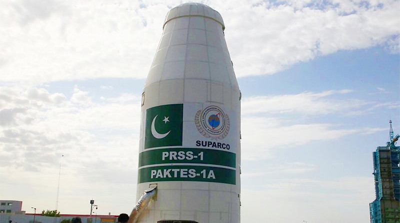
Pakistan successfully launched Remote Sensing Satellite-1 (PRSS-1) in order to cater non-traditional security challenges. The Satellite is equipped with a high resolution optical payload that enables to meet its imagery requirements in the areas of land mapping, agriculture classification and assessment, urban and rural planning, environmental monitoring, natural disaster management and water resource management for socio-economic development of the country.
Pakistan is capable enough to deal with the adverse effects of natural disasters through early warnings systems, technological advances in building and infrastructure construction, improved sanitation systems, increased disaster preparedness and having effective emergency response strategy.
Water scarcity is another area of great concern for Pakistan as it is heavily dependent upon agriculture sector for its economy. Secondly, Indian aggressive policies have always been a source of concern for Pakistan when it comes to water disputes. Pakistan is a lower riparian state but still suffering because of Indian brutal polices. PRSS-1 has proven to be beneficial for water remote sensing. RSS is significant in dealing with the dynamics of water quality and quantity demand.
Remote sensing is also commonly used for crop classification, yield forecasts, and also for monitoring post-harvest residues and on-site meteorological conditions. Pakistan is an agricultural based country so RSS capability is being used for crop classification and track changes which helps in improving forecast of production. SUPARCO conducted a detail study of the fog which affected the crop production. Likewise, the annual production of crops can also be easily assessed through this and SUPARCO has been successful in helping the policy makers. SUPARCO also provides environmental consultancy / services to various users.
Furthermore, SUPARCO in collaboration with Jinnah Post Graduate Medical Centre (JPMC) has established a satellite communication based telemedicine network as pilot project which has been successfully established using a very-small-aperture terminal (VSAT) antenna. Live Video conferencing has linked specialists in JPMC to patients in rural areas thus providing specialist health care services to the rural areas.
Thus, Pakistan is fully determined to fight the nontraditional security threats by using space technology. In this regard, Pakistan’s Remote sensing technology is aimed to play significant role in disaster management especially during the awareness and reaction phases. Space technology could provide not only cost efficient and effective methods of water management but also accurately monitors and predicts long term trends of depletion of resources.
*Misbah Arif, is a Islamabad based researcher and visiting faculty at Fatima Jinnah Women University, Rawalpindi.